Translate

Thursday, January 31, 2013

Dags!(dogs)

Someone named him bimbo, poor dog
seriously, who names their dog bimbo?? especially a Labrador! this was taken in Panaji, Goa, the owners treat this guy badly he comes over to our place for food, you can't say no to those eyes!. He is a 1year old think there is something wrong with his right forefoot, it appears bowed, in the picture if you observe that foot is turned outward and no its not just in this pic he even walks funny and always sits like this! He needs a vet! anyone out there! is it a nutritional deficiency or lack of exercise?? i gots to know!


Kane! complete contrast to the nature of the dog in the pic above
Kane is my friend's Doberman here in Pune, now he is 4 months old and always hyperactive, in the pic he was hungry, that's his way of telling us!! He's got all the qualities of his breed, he's smart, fearless and loyal,
God forbid he turn on my back when he's hungry and sink his teeth into the soft flesh of my butt!!! i like my butt and its integrity!

Tuesday, January 29, 2013

Sita falls, Hebri,Karnataka

The hike to the Sita falls, Im in the far bottom right,
Abhinay is the one at the bottom center 

Sita Falls ( koodlu falls)

zoom in the pic for karnataka tourism office details!
This is one of the coolest getaways after a hard week, it is located about 100km from mangalore and is an ideal day trip. It is located in Someshwar wild life sanctuary part of the Kudremukh range on the road that connects Hebri to Agumbe. Its a126 foot high fall of the Sita river,there is a waterfall above Sita falls but it is too steep for humans to access, only monkeys can be seen up there!!

What you need: a change of clothes, lunch as you will be spending the afternoon at the falls

How to get from Mangalore to Hebri: We went motorbiking we started at 7am in the morning stopped at udupi for breakfast and continued to Hebri we reached the falls at 1030am,since we stay near NH17 that goes to Udupi we took this route,    


This is a slightly longer route than others,head from mangalore to Udupi-Manipal on NH 17 then at Manipal filling station head on to SH 65 this will take you to Hebri which is about 40km, distance from Mangalore to Udupi is about 60km, it should take about 90mins to reach Hebri from Mangalore.
large temple arch, this road  leads to sita falls
From Hebri town head toward Agumbe if you are first time visitor do not hesitate to ask for directions, after about 15km from Hebri toward Agumbe you should see a giant board (the pic at the beginning of this page) this is hard to miss and it's on the right side with a large temple arch.
From here on the ride gets fun if you are on a motorbike, the tar road lasts for another 4 km and then there's a long dirt road buses and cars cannot go this route, so you either trek about 7km along the road or if you've got a mountain bike this will be a enjoyable ride, we had motorbikes.
The narrow bridge
cold water!
the trail to the falls
about 4km along the dirt road you reach a very narrow bridge with space only for one motor bike, another 3km along the dirt road will lead you to a place where you can hear a river, keep looking to the left where you will see a log which is kept across to block the road. We parked our motorbikes and walked toward the river, we washed here, the water in january can be quite chill! cross the river and  head to the falls which is a hike of about 1.5km along a trail. Carry a stick as this area is said to have many snakes
Once you reach the falls take out your camera and enjoy, jump into the pool at the bottom of the falls, you can even stand right under the falls during the drier months from december to april, the pool has a maximum depth of 6 ft.


This is a trip worth going enjoy!! besides if you have more time there is river rafting at Agumbe and great trekking spots too! contact the Karnataka tourism department.
KARNATAKA TOURISM REGIONAL OFFICE UDUPI , OFF CAR STREET ROAD
CONTACT NUMBER: 0820 2529718


Mangalore air crash 2010

Mangalore Air Crash 2010


This is an account of my personal experience of this tragic accident in which 158 lives were lost,

May 22nd 2010 at 630hrs air india express IX812 from Dubai carrying 166 people crashes at Bajpe airport Mangalore after it overshot the runway while landing.

My day began, a regular saturday morning, I didn't have my morning class so i slept in oblivious of what was happening in mangalore. For some reason unknown to me at the moment my cellphone kept receiving messages and I kept ignoring them till I got annoyed to see who was trying to ruin my saturday, the messages I received were from family ,the news alerts that i subscribed to. Message after message making me aware of the current events.
A J HOSPITAL EMERGENCY AND CASUALTY
Initially I just could not believe that this actually happened to this quiet little coastal city, i had no access to a T.V so I called my family to bring me to date with the news, when i confirmed what was going on my reaction was just "HOLY MOLY" jumped off the bed got dressed and rushed outside, you could hear the wailing ambulances in the distance.
the plane overshot the runway and ripped through the vegetation
to crash in the gorge below
the gorge were the plane crashed
I still couldn't comprehend the situation so I went down to The hospital, and yes there was a whole bunch of people police personel and ambulances in front of the emergency department, most ambulances were being redirected to the morgue at the medical college where i was a 2nd year med student, our hospital happened to be the nearest and most equipped to handle the casualties of the disaster.
The scene at the morgue was gruesome you could only recognize the charred bodies as human by the stumps left of the limbs, individual identification was almost impossible.

the only recognizable part of the plane
Wanted to go out and help but we had no leadership nor were we asked by anyone to go for the rescue and relief measures. By around 2pm we had news that some of our senior students had gone out voluntarily to aid in the rescue. The airport is 15 km out of our way and we had no mode of transport to get to the crash site.
We gathered a group of like minded people and decided to head out, three of us borrowed a motorbike from our friend and rode triple( illegal anywhere in the world) we had our doctor coats on and when we got to the police barricades blocking traffic toward the airport, they let us through! when we stated our intent and of course they required our ID proof.
We reached the crash site at 4pm and immediately seeing our medical coats the rescue team asked us to arrange ambulances and to set up camp to provide first aid. We immediately called our Interns and explained the situation, they got permission from the AJ Hospital medical director who gave us the green light to whatever equipment and meds that we needed.
the dead being carried out
The meds and ambulance took some time to get to us during that time we took the role of rescue volunteers but unfortunately there were no more survivors, we had to help carry out the dead in stretchers from the bottom of the gorge by forming a human chain. While we were busy pulling out and carrying bodies there was a sudden unrest in the otherwise focussed rescue, everybody started to rush out of the gorge as the roar of a plane could be heard from the airport, it took off right above our heads, my heart was in my mouth for a few moments, i was near the bottom of the gorge with no way to get out! contemplating the possibility of the worst outcome! the airport was functional by 530pm 
this caused a shrill down everyones spine!

As soon as the ambulance arrived we began to set up camp and informing the rescuers  of the availability of first aid and medical care. We became medical volunteers putting into use our skills, this filled us with a sense of satisfaction that we were able to help in a little way. The rescue efforts were called off by 730pm as all the passengers on the ill fated flight had apparently been accounted for.
rescue efforts called off at 730pm


All that was remaining was to find the black box ( its actually orange and called the flight data recorder), I thought this was going to be especially tough given that earlier in the day a group of opportunistic locals had apparently been taking items from the crash site which included money, jewellery, bags, boxes, this led me to think of the possibility that someone had taken the black box home!

After the rescue operations co-ordinators left we still had to manage the huge queue of firemen and local volunteers, there were 6 of us to handle the entire crowd!! Later a reporter for an American news channel came to us and asked for an interview, the guys pointed at me and i had to answer her questions. When we returned to our hospital we smelled like jet fuel and charred flesh, we had to get rid of the clothes we wore that day, none of us slept that night the scenes of the morning kept playing in our heads.

i will never forget that rainy day in May, My deepest condolences to the families of the158 victims, nothing we do can replace them, we can only cherish the memories that they left us with, they died a cruel death but will never be forgotten.

The guys who i need to really thank for their sincere efforts that day: Dr Alexander Paul, Dr Pradeep Senapathi, Ivan Mani, Arun George, Midhun TT...
though the little we did, you guys are real heroes


Monday, January 28, 2013

hooot hoot!!


spotted this owl near my apartment in pune, i think its a spotted owl, any ornithologists out there?

 took me a looooooooooong time to get one decent picture of this owl, did a little research, this owl is most likely a spotted owlet,common in India and adapted to life in big cities, its found across India and feeds on insects,small lizards and rodents it attains an average height of about 21cm, kind of small.
the smallest owl is the pigmy owl adults reach a height of 13.5 to 30cm! ANY ORNITHOLOGISTS OR ANYONE OUT THERE WHO KNOWS ABOUTS OWLS?, I GOTS TO KNOW! ARE MY FACTS RIGHT?


Sunday, January 27, 2013

Trek to Visapur Fort, Malavalli,  Pune

Visapur Fort is one of the most enjoyable treks in Maharashtra, it is located near the town of malavalli which is 3km from lonavalla and 60 km from pune, it lies just off the pune-mumbai expressway. 
There are 2 forts( visapur and lohegad) in malavalli and an ancient cave( bhaja caves).
Visapur fort is much larger, higher and less accessible compared to the Lohegad fort, this is the reason why much fewer people trek to Visapur. Visapur fort is approximately 1084 meters above sea level.


How to reach Malavalli from Pune: you can take the old Pune Mumbai highway or take a local train from Pune central to Lonavalla, you should reach in 90mins the train stops at Malavalli station. Recommended that you start early from Pune by 630am.
malavalli station
please note the date and time are wrong in this photo
correction: 26/8/12 at 7:45am

Best time to trek here: Monsoon from july to september

What you'll need:
 1.Good trekking boots, sneakers are not the best as the route is very slippery, pants                                   and a full sleeve shirt as there are thorny plants along the path, carry a small pen knife too. Trekking here alone isn't such a great idea
 2. A raincoat if you don't like to get wet
 3. 3 liters of water
 4. Snacks to eat along the way
 5. Carry your cell phone as there is reception even at the top, besides it is very easy  
     to get lost here
 6. The entire trek should cost you only a maximum of Rs250 and that includes          
      everything!
 7. Carry a camera!

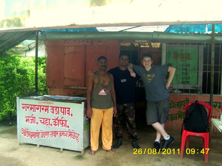
 Starting the trek: start from malavalli station and head towards malavalli village you have to take the bridge across the Pune-Mumbai expressway and then take the road to the right which heads toward malavalli. It is a 3km walk to the village you also have the option of taking an auto rickshaw,If you'll have  reached the village by 815am, here you can have a nice hot breakfast, when we go trekking here we prefer to take a nice wash in the waterfall just beside the village, trust me this is truly refreshing feeling and wipes that 6 'o' clock face right off you.

Ashok kaka's hotel
the waterfall

nice hot masala chai
Breakfast at Ashok kaka's hotel where you can have a nice spicy mistle pav and hot masala chai! after bath and breakfast the endorphins are coursing through your veins and you'll be eager to begin the trek!!


sizing up our destination hidden in the clouds
one of the numerous waterfalls along the way


The routes suggested below are from our experience at Visapur, the description of the routes is very vague and i strongly recommend that you USE YOUR OWN BRAIN AND GUT INSTINCT!

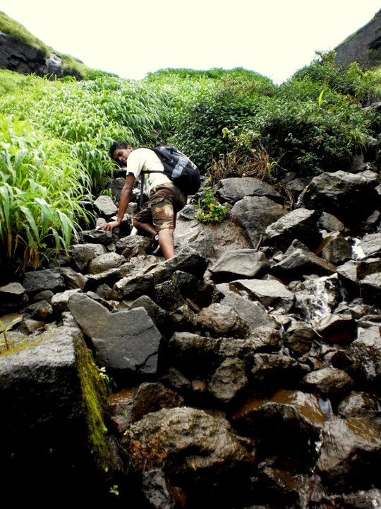
 Routes to visapur: the regular route is the main dirt road leading to the valley between the visapur and Lohegad forts, to get here you'll have to follow the road for about 4kms along the route there are a plenty of waterfalls to explore but do not waste to much time here because there is a real long way to go.
despite jonathan's demeanor this was a track that got us lost for 3hours!


The road splits the left heads toward visapur, after a point the road ends at a dead end. important: keep to the main road other tracks lead to dead ends! the 1st time we came here we took off on a track and got lost for 3hrs this really annoyed us. 
the right way up! the waterfall
From our experience, you should stay on the road till you reach a tiny hut from here you have to find a waterfall behind all the overgrowth of greenery this can be quite a challenge as the bush is very thick and very high, find a good stick that you can push through the bush and can use as a snake stick just in case you run into one, believe me this part is pretty spooky! once you reach the top its an exhilarating feeling!!

the waterfall, Nathaniel(bottom) and George


The other route to the top: Walk up the stairs to Bhaja caves at a point about 3/4th the way to the caves trek off the stairs to the side of the hill and trek toward Visapur, there is no track here so initially you'll have to go with your gut, as you keep trekking you should reach a house at the top of the first hill, from here look up to the fort and head in that direction, you will start trekking downhill for a while and from a distance you should see a second house, do not head toward the house instead search for a path that winds up in the direction of the fort and follow it.
trek off the stairs from here


the bush is taller than jonathan except here!


flagstaff at the top

The path will lead you to a point where the bush grows over your head, keep to the path, it will lead you to the base of the wall of the fort, at first sight you may see a dead end but trek just a bit toward the right and you will find a rock which you can climb, once you climb the rock walk to the left you will reach the fort wall and then you will see a staircase headed down and then into the fort, this will lead you straight to the flagstaff at the top!! I have not included the amazing shots from the top, i would like you to see it for yourself!


Getting down: the best way to get down is the stairs from the Hanuman Mandir, the stairs last for a while and then become a waterfall on the rocks, keep to the water and follow it till you cannot follow it further, then trek toward the right and try to find a trail on the hill, you will be able to see the visapur village and the expressway from the where you are keeping that in mind trek across the to the adjacent hill, this is especially tricky and you may end up lost even if you've been here before, once you hit the right path it will keep winding down and you will soon see villagers with their cattle, ask your way down from there.


hanuman mandir

the stairs end, the way down

stairs leading to hanuman mandir

follow the water


take your time and do not slip!

the village can be seen from here through the fog
The trek should end at Visapur village by 530pm which includes ample time to explore the fort and for photography and also plenty of time to get lost and then find the right way!!!

trek to jamalabad fort belthangadi, karnataka

Jamalabad rock(Gadayikallu) 1700ft above sea level 2000 stairs to the top!
Jamalabad Fort is located in Belthangadi D.K district( there is a Belthangadi in Shimoga district), Karnataka, it is locally known as "Gadayikallu", it was built by Tipu Sultan ruler of the region in 1794. He named the fort after his mother Jamalabee.
The fort is 1700 feet above sea level and has close to 2000 steps to the top

How to get there from mangalore: Distance 65KM, Government and Private buses are available through the day, Government buses are available from the mangalore KSRTC bus stand, we started a 530am took the bus and reached by 730am, if you plan to take your own transport then you should take NH 234. The government buses take 2hrs because of the numerous stops along the way.

road from Manjodi

the way to the base of the fort
TREK HERE ONLY DURING THE DRIER MONTHS OF DECEMBER TO MAY, TREKKING IS NOT ADVISED IN THE MONSOON.

What you need: this is an easy trek, but requires a good deal of endurance as the steps are quit steep at most places! the entire trek should stay within a budget of Rs 300
take 3lts of water per head and snacks to munch along the way, you can have breakfast at belthangadi town near the bus stand there are plenty of hotels.
Take a hat
Carry sunscreen
Carry a camera!!

How to get to the fort: from Belthangadi town you can take a local bus to MANJODI this is approximately 9KM from the main bus stand, you may also take an auto rickshaw if you don't mind spending a bit!

the walls of the fort!
From Manjodi you'll have to walk along a tar road toward the fort for about 3km, along the way you will cross a river, you can freshen up here before and after the trek, believe me this is a relief in the summer!!
Once you reach the fort you will realize that this is a national monument and is protected by the ASI (Archaeological Survey of India) so please do not vandalize.
If you arrive early enough you can beat the gatekeeper and can get a free entry, however you'll have to pay it when you come back down! ha ha! the rates are different for children and adults and citizens of India and Foreign tourists.
Overnight stay is prohibited on the fort. The trek should take around 90mins for a regular person, the steps are very steep for most of the climb!

steep stairs! 2000 of them!!

The Kudremukh range is seen in the background

Headstand!

for more information contact


Department of TourismGovernment of Karnataka
#49, 2nd Floor, Khanija Bhavan, Race Course Road,
Bangalore 560 001
Tel: 080-2235 2828, Fax: 080-2235 2626
Email:info@karnatakatourism.org


Karnataka State Tourism Development 

Corporation Ltd (KSTDC)
Badami House
Main Booking Office & Tour Starting Point:
Opp. Bruhat Bengaluru Mahanagara Palike Office, N.R. Square,
Bangalore 560 002
Tel:
 080-4334 4334, 4334 4337, 089706 50070 (6.00 am to 8.30pm)
Fax: 080-4334 4353
Email:
info@karnatakaholidays.netWeb:www.karnatakaholidays.net

Jungle Lodges & Resorts LtdNo.49, Ground Floor, West Entrance, 
Khanija Bhavan, Race Course Road, 
Bangalore 560 001
Tel:
 080-4055 4044
Email:info@junglelodges.com 
Web:www.junglelodges.com


The Golden Chariot
No. 8, Tourism House,
First Floor, Papanna Lane,
St. Marks Road, Bangalore 560 001
Tel:
 080-4346 4341, 4346 4346
Email:project.director@goldenchariot.org
Web:www.goldenchariot.org